Flood maps are integral for first responders, disaster managers, insurers, and municipal and country-level governments to prepare, respond, and recover from disasters on the ground. But most of those flood maps, including those used by FEMA, rely on simulated modeling that depends on limited ground and historic data. Not only are these models costly and time intensive, they can also entirely miss floods in regions not historically prone to flooding. As a result, the full scope of global flooding has not been fully understood — even as climate change accelerates.
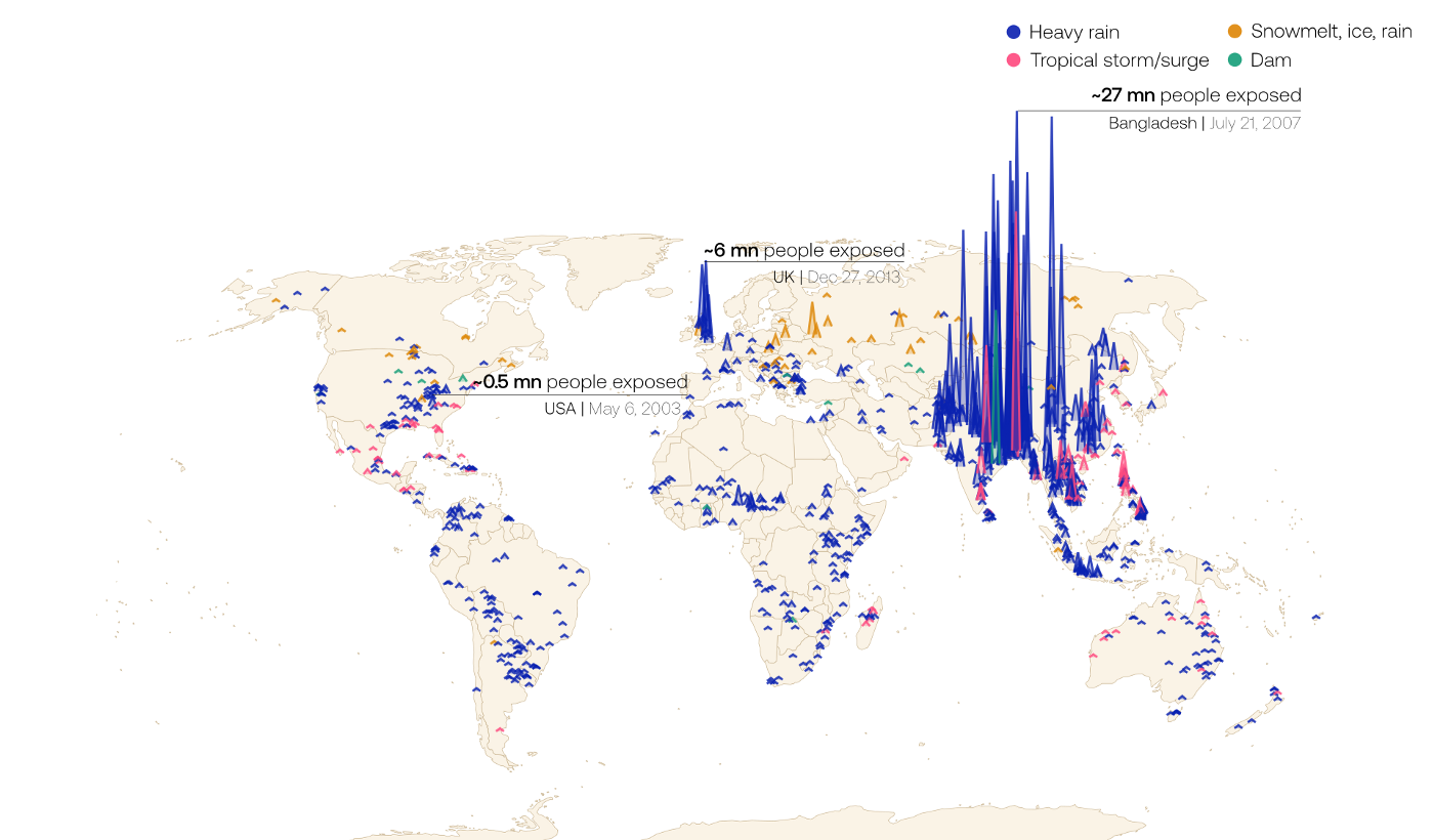
New research published in Nature and made available through Cloud to Street’s Global Flood Database uses direct satellite observations of floods to leapfrog those limitations — and reveal that the global population at risk of flooding is increasing at a more quickly than scientists previously thought. The numbers are staggering: since 2000, the proportion of the global population exposed to floods has grown by 24 percent, ten times higher than previous estimates. The result of both increased flooding and population migration, this marks an increase of population exposed to flooding globally by up to 86 million people.
“We found that economic development and people moving into flood-prone areas is significantly increasing the number of people exposed to floods in these regions. Furthermore, increasing flood exposure is rooted in underlying conditions that give vulnerable populations no choice but to settle in flood zones,” says Dr. Jonathan Sullivan, post-doctoral scientist at the University of Arizona and research co-author.
These patterns — and the research behind them — are viewable to all at the Global Flood Database, the world’s largest open library of flood maps. Led by the scientists at Cloud to Street with co-authors from NASA, Google Earth Outreach, and six top universities, the Global Flood Database combines over fifteen years of satellite observations with human settlement data to offer a comprehensive look at the true — and changing — impact of flooding, both globally and locally.
Accurate data is critical for responding to floods as they worsen — and for preparing for life on a warming planet. As lead author and Cloud to Street co-founder and Chief Science Officer Dr. Beth Tellman explains, “Using satellite observation data of floods with improved spatial-temporal resolution will help policymakers understand where flood impacts are changing and how best to adapt. The Global Flood Database can improve the accuracy of global and local flood models and vulnerability assessments, increase the efficacy of adaptation measures, and deepen our understanding of how land cover change, climate, and floods interact.”
Have questions about the Global Flood Database? Want to learn more? Join the waitlist for a premium version or sign up for an upcoming webinar about how to use the tool here.
Interested in careers at Cloud to Street? See our current openings here.
